This is a paid asset, but now you can download it totally free from our site with high speed. However, please keep in mind that this package is only provided for studying or testing the product prior to purchasing it, not for business functions.
Overview
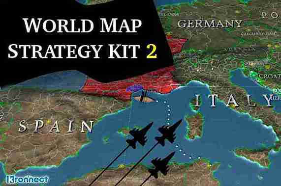
World Map Strategy Kit 2 is a powerful game toolkit for creating strategy games based on real or fictional world maps. Includes great visual-appealing features that are complex to implement to provide you with an AAA kickstart in developing your game.
Visual Features:
- 4 main view modes: flat map in 3D, flat map in 2D (UI element), custom 3D viewport with relief, and Unity terrain mode (projects map features on standard terrain).
- Exclusive custom viewport with 3D surface mesh for terrain with customizable/realtime height, infinite horizontal scrolling (world wrap) and gorgeous effects (water, coast foam, buoyancy effect, frontier lines, PBS-based)
- Several Earth background textures and styles included, from 2K to 16K High-Res.
- Cloud layer with animated drop shadows over terrain.
- Artistic and animated Fog of war with simple API to clear fog over a zone of control, country or province
- Animated, thick / smooth country borders! Use sample textures or add your own with custom color, width and patterns
- Curved map mode.
- Day/night cycle.
- Optional minimap for quick navigation.
- Smooth runtime switching between 2D and 3D viewport modes
- Dynamic country and province labels with adaptive text to the terrain.
- Smart country label placement algorithm with curved text using TextMesh Pro!
- Line drawing system with animated dashing line support to show routes, throwing arcs, on-terrain paths,…
- Tickers/banners support. Add scrolling / blinking messages over the map easily.
Map Features:
- Offline features (does not require Internet connection):
- WGS84 datum: real-world cartography included for countries and provinces. Includes country-specific FIPS 10-4, ISO A2, A3 and N3 standard codes.
- the frontiers of +4400 provinces, +7100 cities and +240 countries. Country frontiers on high and low scale.
- Cities are classified as normal cities, regional capitals, and country capitals.
- Online and offline map tile systems support zooming up to street level. Includes cache and tile downloader assistant. Supports OpenStreetMap, Stamen, Carto, Wikimedia, ThunderForest, OpenTopoMap, MapBox, Sputnik and AerisWeather services out of the box (service may require special license). Ability to connect to custom tile servers.
Other Map Features:
- Map Editor for creating or modifying countries, provinces, and cities, including a territory importer tool that automatically creates frontiers based on color textures.
- Map Generator: create random world maps including countries and province borders, cities, random names, and textures (heightmap, background texture, water mask, etc.) using a few sliders, options, and buttons!
- Customize the map as you wish: change textures or water/fog color, add textures to provinces or countries, or color fill them, … at design or runtime.
- Mount Points support. Define your own strategic landmarks with location, type and custom attributes over the map to easily use them during the game for positioning units, buildings, control zones, etc.
- Merge/conquer map regions at runtime.
- Grid & Path-finding Features
- Hexagonal grid optimized for low vertex count and highest frame rate. Color/texture any cell. Cell effects like blink, flash, and fade out.
- Path-finding engine based on A* algorithm for unit movement. Assign terrain capabilities to your units and they will automatically take the optimal path. Paths can be calculated based on world positions, country to country (Risk style), province to province or hexagonal grid cells (classic strategy games).
- Define cell crossing costs per cell or per edge.
- Roads.
Interaction Features:
- Fully interactive map and touch compatible: zoom, pan, scroll, pinch to zoom, etc.
- powerful Powerful Highlighting system for selecting countries and provinces.
- Fly to any country, province, city, location with custom speed and zoom level. Close zoom to specific country, province, or region so it fills the screen.
- Make camera follow automatically any unit on map.
- Infinite scroll option (world wrap)
- Rectangle selection. Click and drag to draw a rectangle to select units.
Developer Features:
- Easy-to-use and documented API for units positioning, selection and movement over the map (locations based either on lat/lon, plane/2D coordinates, or country/province/city names).
- One line of code to move units over map according to terrain capabilities (water, land and air units), terrain costs, elevation constraints, etc.
- Custom attributes for countries, provinces, cities, mount points, grid cells and game units. JSON support.
- Calculator. Convert from lat/lon to plane coordinates and vice versa.
- Comprehensive documentation (91-page manual).
- 42 demo scenes, plus YouTube tutorials and sample videos showing key features
- 100% C# source code included.
- Compatible with built-in and URP pipelines.